|
The following paper was delivered at the 1995 Society of Architectural Historians Annual Meeting, Seattle in the session entitled "The City as Monument." Subsequently, it was published at Quondam 1997.03.27.
Methods of Archaeological Reconstruction in Piranesi's Il Campo Marzio dell'antica Roma (1762)
Susan M. Dixon
 The Ichnographia of Il Campo Marzio dell'antica Roma
| |
Architectural historians most often refer to Giovanni Battista Piranesi's Ichnographia, the foldout plan which is the largest and most impressive although just one of the forty-two illustrations in the publication Il Campo Marzio dell'antica Roma of 1762, in terms of attitudes it embodies about urban design or the creative process. Manfredo Tafuri and Jennifer Bloomer offer the best examples of such explanations of the plan.
Less seriously regarded is the fact that Piranesi intended the plan as an archaeological reconstruction of a section of Imperial Rome. The literature has long dismissed the reconstruction as not only inaccurate but highly fanciful. By late twentieth-century standards, it is both. However, the dismissal ignores the issue of what constituted archaeological reconstruction in Piranesi's day. The illustrations and accompanying text of Il Campo Marzio testify to the artist's use of methods then known and acceptable, if not universally used, in eighteenth-century Italy.
Here I discuss the Ichnographia in term of these methods. At the end of the essay, I will argue that one of the purposes of Piranesi's methods was to create a holistic vision of the Imperial city, to view Rome as the monument and its buildings as building blocks or facets of that monument. This vision is rare among reconstructions previous to Piranesi's day. In earlier studies, for example, Pirro Ligorio's Antiquae Urbis Imago of 1561, or any of the renderings of ancient Rome by Palladio, the individual buildings are the starting and end point of the reconstructions. Piranesi's holistic vision was rare in his own day. Compare his work with that of his contemporary. The map illustrating the archaeologist Ridolfino Venuti's Descrizione di Roma antica of the late 1760s. (Indeed, Piranesi's vision is rare for own century; see the many reconstructions of Rome by Rudolfo Lanciani.)
|
The Methods
| |
In general in the eighteenth century -- and Piranesi's archaeological work is not an exception to this rule--the ancient object (be it a work of art or architecture) gained great stature as historical evidence, greater stature than the ancient writings--e.g., the texts of Livy, Suetonius or Herodotus. The objects were considered more truthful, and more immediate sources of information, if means could be devised to interpret those objects successfully and correctly. The writings, on the other hand, were subject to great scrutiny. They were found to be deficient, laden with the author's subjective opinions or peppered with myths and legends. Arnoldo Momigliano first noted this some 50 years ago, and more recently, Francis Haskell elaborates on this phenomenon.
Problematic for the eighteenth-century archaeologist/historian, there were bound to be great dark pockets of the unknown and the unknowable, pockets which neither object nor writing could illuminate. (This situation was a product of the age of Enlightenment's desire to objectify the past as something which existed wholly and yet separately from the present. This desire existed coincidentally with one which still wanted to use the past as something which supported the policies, be they political or theological of the present; herein lies what makes the eighteenth-century's study of history interesting.) As there were great gaps in the knowledge of the past, great leaps were then needed to supply the holistic vision of the past which was the aim of scholars--archaeologists and historians--like Piranesi.
In the Ichnographia, Piranesi filled the gaps, and he (and others like Francesco Bianchini) justified the filling. He employed three major means:
1. a use of common sense
For example, if two literary sources stated conflicting information about a historical situation, the one which was written some centuries after the situation was scrutinized more critically. More importantly, if a literary source stated something contrary to what common sense dictates, then that source was overruled; or if the written sources were silent, then common sense becomes the means by which to make judgments. Specific to the Ichnographia, the jail of the early Republican times could--by the dictates of common sense and what was known about the population in early Republican times--only be of a certain scale. Furthermore, it could only be located in a specific area in the Campo Marzio--near the river, as this was a practice in ancient Rome. Likewise, it could only be located beside the Temple of Piety, because a famous early Roman legend links these two structures together.
2. a factor of likelihood
This is the notion that there were similar objects, similar functions, similar sets of circumstances known about one extant artifact, which could be used to explain and reconstruct another similar artifact. To this belief, Piranesi made his intentions very clear when he stated in what is arguably the most famous quote from the text: [one could] "examine the [extant] villas of Latium and that of Hadrian at Tivoli; the baths, the tombs and other ruins outside the Porta Capena (south of Rome)," to find architecture which would look like that in the Campo Marzio, and therefore justify his reconstruction of buildings in the Ichnographia.
3. a reliance on a universal imagination
This is the most unusual method for us in the twentieth century to identify with. This imagination was fed by memory (which held historical knowledge), and was acted upon by fantasy. Artistic input, which drew upon this imagination, was highly valued by archaeologists in their works of reconstruction. Piranesi referred to this method as "rational conjecture (ragionevole congetturo)." (He clearly is defending his methods against those critics in his day who considered his work capricious.) Hence, Piranesi underscored his value as both artist and archaeologist in his work on the Campo Marzio because it made him the consummate uncoverer of knowledge.
|
Description of the Publication
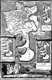 Plate 2 from Il Campo Marzio dell'antica Roma
| |
After sixty-nine pages of text--which appears in both Latin and Italian--there are a series of three plates each crowded with various maps, some of them represented as layered one atop another in trompe l'oeil frames; some represented as if they too were incomplete ancient artifacts in need of reconstruction.
The first plate corresponds to the information in Chapter I of the text which is concerned with establishing the boundaries of the historic Campo Marzio, boundaries as dictated by topography--hills, valleys and rivers.
The second and third plates illustrate a total of seven maps of the same area. They correspond to the states of development of that area, following a chronology which Piranesi has outlined in Chapters 2 through 6. Five of the maps outline what Piranesi identified in the text as the five states of development of the site: Rome from its founding to the age of the Kings; Rome during the early Republic, before the time of the Consul C. Flaminius (c. 500 to c. 200 B.C.); Rome during the late Republic, until the time of Julius Ceasar (c. 200 B.C. - 19 B.C.); Rome during the early Empire, especially during the reign of Caesar Augustus (19 B.C. 31 A.D.); and lastly, Rome during the reign of later Emperors who completed many of the works begun by Augustus (1 st through 3rd century A.D.). In this series of maps, one reads the number of buildings in the Campo Marzio increasing and the density thickening.
The next plate of the Campo Marzio, though, tells a different story. It is the Ichnographia, in which Piranesi filled in the city. It seems to be a logical step in this sequence of maps described above. It represents the Campo Marzio as it would have existed in its most magnificent and dense state, in the late Empire, in post-Hadrianic Rome. However, there is no obvious logic as to how Piranesi arrived at this point; the text fails to explain the majority of what is depicted here. The connective tissue between the major monuments which together constitute the city miraculously and imaginatively appears in the large map.
The plates which follow the Ichnographia are in the main vedute. They depict the major or identifiable ancient buildings as they were extant in the 1750s and 60s when Piranesi illustrated them, but with the debris of the intervening ages - between the fourth and eighteenth centuries - removed. In other words, the views underscore or represent the gaps to be filled in.
|
Methods of Reconstruction Utilized
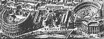 Birds's-eye view of the theaters of Marcellus and Balbus from Il Campo Marzio dell'antica Roma
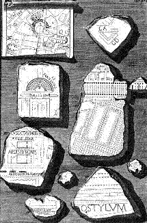 Fragments of the Forma Urbis from Il Campo Marzio dell'antica Roma
| |
To describe Piranesi's methods of reconstruction, I will focus on three specific sites within the Campo Marzio which are depicted on the Ichnographia.
The first is the area around the theaters of Marcellus and Balbus, both architectural works created in the age of the late Republic. Piranesi not only reconstructed the area in plan. He also chose to represent it in a bird's-eye view; it was one of three small areas singled out in this manner.
The evidence which Piranesi identified as available to him include: the literary ones, e.g., Pliny and Cassiodoro. Most significantly, the literature informed Piranesi of the presence of a cryptoporticus near the Theater of Balbus. No visual evidence of this underground passageway had survived, and so the literary sources were important.
Visual evidence, too, served him. There was primarily that which remained in the city, particularly the large portion which remained of the Theater of Marcellus, converted throughout the ages first to a fortress, then to a palace of the great Renaissance and Baroque families. There were various other artifacts -- he mentions fragments of seats and entablatures, and two walls which were found in the cellar of a wineshop in the area, which he identified as the corridor of a vomitarium of the theater. Included in the category of artifacts were an early sixteenth-century drawing by Sangallo the Elder of the Theater of Balbus, and a later sixteenth-century sketch by Duperac of the Theater of Marcellus, both of which were used fairly uncritically as evidence of what the theaters might have looked like in ancient times. Lastly, among the visual evidence was the Forma Urbis. This highly fragmented marble plan of ancient Rome supplied Piranesi with evidence of the form of the Portico of the Theater of Marcellus, located behind the stage area. Piranesi accepted likelihood as a method of reconstruction, and this enabled him to consult another famous theater, the Coliseum, to aid in reconstructing the details of the two theaters.
Even with this evidence, Piranesi must have come to an impasse. He then employed imagination or "rational conjecture" to fill in the gaps. But first Piranesi acknowledged the gaps. He did so in the text and in the illustrations of Campo Marzio.
|
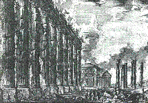 Remains of the Temple of Antoninus Pius with the Pantheon in the background from Il Campo Marzio dell'antica Roma
| |
In chapter 1, Piranesi criticized those ancient writers who explain the Campo Marzio in terms of defining geography or the activity housed there rather than buildings. His goal was to focus on the buildings. However, he was keenly aware that the buildings "do not hinder the military exercises, but rather they facilitate or allow them." The places where the built monuments allowed human activity, the gaps, were of importance to him.
In the majority of the plates, he represented these gaps. Using a genre or type of representation new to his work, Piranesi created vedute in which he focused on an ancient monument but removed the accumulation of things built in the medieval, Renaissance and Baroque times, the intervening ages of time. Piranesi did not use such vedute in any previous publication, and I have not seen it in the work of other archaeologists of Piranesi's day. The absence is astonishing. It appears that the gaps are the subject of these vedute. The area was cleared to allow for a rationally conjectured reconstruction of the city in which the ancient theaters were just actors.
I will just briefly focus on the building between the two theaters--what Piranesi identified as the Minucio Vecchio, a portico which once served as the point where grain was distributed to the Republican troops. It was well known in its day for housing a famous statue of Hercules. Piranesi gave this structure a highly unusual form. Sources for this unusual plan and elevation--particularly that of the curiously domed roof--were derived from tomb structures on the Via Appia, and buildings in Hadrian's villa complex, which Piranesi had illustrated in other publications.
Piranesi assembled these buildings--the theaters and the portico--positioning them one in relation to the other. The jail of Republican times, the Temple of Piety, the various porticoes collide, or perhaps nestle, with the temple structures, to facilitate processional movement among them, movement which Piranesi acknowledged with a dotted line on the map.
The infill Piranesi supplied in the Ichnographia is more astonishing than the gaps he represented in the vedute. It clearly underscores Piranesi's artistic intervention in the reconstruction. As he admitted, it was his choice of things which "more than others allow one to know more than one is able," in other words, it was his intervention with the evidence which allowed him to advance beyond the known, to create historical knowledge, to allow for valid reconstruction.
|
 The complex behind Hadrian's Tomb from the Ichnographia of Il Campo Marzio dell'antica Roma
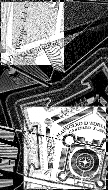 Detail of the Nolli Plan of 1748 highlighting Hadrian's Tomb (lower right) and "vestiges of the Circus of Hadrian" (upper left)
| |
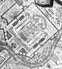
The second example I choose is the complex around the Tomb of Hadrian with its various tomb structures, its crematorium, its circuses and porticoes, and the bridge which unites the moated complex to the Campo Marzio proper.
Again, Piranesi consulted an abundance of literary evidence, i.e., the Life of Hadrian and Procopius' account of the ancient buildings which described this work. As the mausoleum of Hadrian had been altered from its original form as early as 400 A.D., when it was converted into a fortress, the descriptive literary sources were very helpful.
The visual evidence included the extant, although highly changed, building of the mausoleum and the bridge. But the visual evidence also included the sketches and reconstructions of earlier generations. Piranesi regarded them with critical common sense, (his footnotes to the text highlight his criticism) but used them nonetheless.
As for the architectural elements within the mausoleum complex - the pools, paths and gardens, and particularly the circuses - some of the visual evidence had only recently been acquired. Excavations of the 1740s had just uncovered archaeological evidence of a circus; this information was presented in the Papal academy dedicated to ancient Roman history. But the remains were scant, as the Nolli map of 1748 suggests.* Piranesi's common sense, and his knowledge of the rules of architectural symmetry as dictated by Vitruvius gave the artist license to reconstruct the Hadranic complex as we see it, with two symmetrically placed circuses.
The circuses extant within the city of Rome, e.g., the Circus Maximus, supplied Piranesi with many details for his reconstruction, as did the reconstructions of other ancient circuses, those created by earlier antiquarians who used coins and medallions as their main source of information about the appearance of Roman circuses. And most importantly, the complex of Hadrian's villa offered Piranesi a variety of architectural prototypes, precedents which gave him a familiarity with building typologies associated with the Emperor. Features such as the layout of the tombs and moat are derived from Hadrian's villa.
Ultimately, though, Piranesi's reconstruction is not fully explainable in terms of the evidence he has gathered. Again, the imaginative leap created the unified complex
|
 The Horologium or Sun Dial within the Ichnographia of Il Campo Marzio dell'antica Roma
| |
Lastly and briefly, I will focus on the Horologium or the Sun Dial. For this monument--composed of the obelisk of Sestorsis positioned amid an inscribed pavement--Piranesi scrutinized the literary sources with unusual care. The function of the monument had long been at issue. Pliny regarded it as a timepiece, but stated that it was in disrepair when he saw it. To Piranesi, then, Pliny's description of the function as sundial was suspect. He, like some of his contemporaries, wanted to identify it as a meridian, or marker to chart the earth's position relative to the sun and other stars in the heavens.
The visual evidence was extraordinarily fragmentary and problematic to interpret because the fragments were unearthed sporatically over two centuries. But Piranesi collected the facts diligently. Fragments of the original pavement, lined with gilt metal, were found in Piranesi's day in basements in the area around the church of San Lorenzo in Lucina. Under the church, inscriptions which would have adored portions of the pavement were discovered. In addition, the obelisk which was used as the needle of the sundial was extant. Parts of it were discovered as early as 1587, and five newly found pieces of its broken shaft were bought by Pope Benedict XIV in 1748.
Piranesi's reconstruction of this "Sundial" is remarkable because despite the literary and visual evidence, he was compelled to use his common sense and the factor of likelihood to reconstruct and in fact reinterpret the work. He turned to a monument which he believed was similar to the fragmented "sundial." This was the recently reconstructed, but in actuality newly constructed, Linea Clemenfina in the Church of Santa Maria degli Angeli, a meridian. Francesco Bianchini, a papal prelate and a learned astronomer, constructed the meridian in 1702 after much diligent research. Piranesi admired Bianchini's work, and emulated it in a variety of circumstances, including in this area of the Ichnographia where Pliny's sundial becomes a meridian.
Finally, the unusual positioning of the monument within the city, as it oddly responds to the buildings around it--the Amphitheater of Statilus Taurus and the complex around the mausoleum of Augustus--illustrate Piranesi's understanding of the Horologium not only as an individual monument, but as one part of a larger urban environment, where movement around and within the monument is considered.
|
|
Conclusion
| |
By the late eighteenth century, Piranesi's highly subjective methods were replaced by the more objective scientifically archaeological ones of, for example, Carlo Fea and Nibby, responsible for the first excavations of the Roman Forum. In these new methods, the sure knowledge of the detail was valued over the imaginative yet coherent understanding of the monument. In other words, the sure reconstruction of a partial building was a more desirable aim than an overview of the city. In the process, the role of the imagination in the making of history was devalued.
These post-Piranesian methods we have inherited. Integral to Piranesi's archaeology was the focus on the city as the monument and the buildings as the media by which to recreate that monument, a holistic focus lost to historians and archaeologists today.
* Thanks to Stephen Lauf for pointing out the "vestiges of the Circus of Hadrian" within the Nolli Map of Rome.
|
| |
|