12 September 1778
12 September 2003
Re: more news from Philadelphia's Logan Circle
I returned to the Benjamin Franklin Parkway to continue virtually walking along the Campo Marzio long axis from Hadrian's Tomb to the tiny 'intercourse' building along the banks of the Tiber.
The most thought/memory provoking Memorial around Logan Circle is the one dedicated to the "Colored Soldiers" who fought in World War I. Remember, the Parkway was executed between the two World Wars. There it is, literally etched in stone, the description of "Colored". Otherwise, it is a very handsome memorial, and evokes an enormous amount of respect.
I am somewhat surprised at the predominate amount of military/soldier memorials within/along the Benjamin Franklin Parkway, and I can't help but see how this all relates perfectly to the Campo Marzio, since the original Field of Mars is exactly were ancient Roman soldiers used to exercise. I [re]read the other night, in Building The City Beautiful: The Benjamin Franklin Parkway and the Philadelphia Museum of Art, how the site of the Parkway, after demolition of the many previously occupied city blocks but before ultimate construction, was used briefly by troops before going to battle in Europe.
Lots of pictures were taken at and around Logan Circle before walking the rest of the axis toward the LOVE sculpture at JFK Plaza (now popularly referred to as "Love Park"). This part of the Parkway is integral to the city proper, thus tall buildings and regular pedestrians (half using cell phones) are in abundance--this contrasts with the Parkway north of Logan Circle, which is several large blocks of mostly open lawn. Just before reaching JFK Plaza, there is the Memorial dedicated to Holocaust Victims, on the Parkway since 1964. In the warmer months, the whole length of the Parkway (on both sides) is lined with the flags of the all the nations of the world--I believe this was started in the late 1970s. The nations are presented in alphabetical order, except the flag of Israel is next to the Holocaust Memorial, just like the flag of the Vatican is next to the Basilica of Sts. Peter and Paul.
John F. Kennedy Plaza/Love Park is one of Philadelphia's 'living rooms', and the Robert Indiana LOVE sculpture has been there (I believe) since the Bicentennial/1976. At first just a temporary installation signifying the meaning of Philadelphia--City of Brotherly Love, the sculpture became an endeared feature of the city and was thus made permanent. When I first took pictures of LOVE in October 2001, a newly engaged couple asked me to take a picture of them in front of the sculpture--the resultant picture was to be part of their Engagement Announcement. During the 1990s, Love Park became notorious as a preferred venue for skateboarders [indeed actually famous in overall skateboarding folklore]. Lots of damage was done, and skateboarding here is now prohibited--although I think special/official skateboarding competitions are still conducted here.
Another Japanese(?) tourist, this time a woman, asked me to take a picture of her at 17th and the Parkway with City Hall in the background.
Getting back towards Logan Circle, I go into the Basilica of Sts. Peter and Paul, where I haven't been in over ten years, and haven't been in while empty in 25 years. For some reason, I found it to be enormous inside. I guess it just is enormous, and actually quite nice architecturally, very Renaissance Rome. I notice within one of the side chapels is the chair used by Pope John Paul II while he was in Philadelphia 1979. Since no one else was around and the railing to the chapel was only 2 feet tall, I decided to go sit in the chair myself. I found those few seconds sitting to be quite intense, so I got up quickly because otherwise I would have gotten way too comfortable.
Well, what do you do after having sat in one of the Pope's chairs? To be honest, I was in a very good mood the rest of the day.
12 September 2010
Bufalini--Nolli--Piranesi 01
"[Nolli's] debt to another plan-map of Rome, the 1551 woodcut by Leonardo Bufalini is more direct. On sheet 35/36 we find Nolli's tribute to the work of this Renaissance topographer. It is a reduction of the original woodcut with changes only in the orientation (north instead of north-east), in the graphical conventions, and in the decorations around the edges. With respect to all of its Medieval and Renaissance predecessors, Bufalini's map represents a remarkable change. From old collections of buildings drawn in elevation or oblique view, with little topographical consistency, and a nearly total absence of indications of streets in plans and views like those of Strozzi and Schedel, we suddenly pass to Bufalini's meticulously complete plan where every street and city block is clearly drawn. The map is not very precise in some of its angles and distances (e.g. the trivium of streets at Piazza del Popolo are shown converging at unequal angles), but it is the first map since antiquity that enables us to grasp the city in its topographic entirety. The varying width of the street is clearly indicated, with wide straight Renaissance streets contrasting with Medieval ones. In its inclusion of ancient buildings in reconstructed form, Bufalini's plan reflects the contemporary interest in antiquity.
Nolli made no attempt to rectify inconsistencies of the Bufalini map when he prepared the reduced copy. The Popolo trivium still has its unequal angles, and the Circus Maximus is still semicircular at both ends instead of one. He did, however, give greater relief than the original to the densely populated part of the city by shading in the city blocks. This is the same graphical convention he used on his own map. He maintained Bufalini's emphasis on antiquity by copying them exactly as in the original. Indeed he acknowledges this aspect by including views of ancient buildings at the bottom, where the map appears to be scrolled up, so as to reveal the "Colonnacce," a broken aqueduct, and the Pantheon (with Baroque additions) in the lower left corner, and the three ruins of the Forum Boarium in the lower right hand corner: The round Temple of "Mater Matuta," the Arch of Janus (with Medieval additions) and the Temple of "Fortuna Virilis."
Allan Ceen, Rome 1748: The Pianta Grande Di Roma of Giambattista Nolli in Facsimile (New York: J.H. Aronson, 1984), p. IV.
"The Grande Pianta includes all of the projects completed or about to be completed in Rome at the time that Nolli was preparing his magnum opus. [...] Many of these contemporary buildings are illustrated in the small Nolli plan (sheet 33/34 [immediately preceding the reduced copy of Bufalini's map-plan]). Here the cityscape was drawn by G.B. Piranesi whose name, together with that of Nolli, appears on the end of an overturned piece of ancient entablature drawn so as to seem protruding from the picture (a Piranesi trademark).
Allan Ceen, Rome 1748: The Pianta Grande Di Roma of Giambattista Nolli in Facsimile (New York: J.H. Aronson, 1984), p. V.
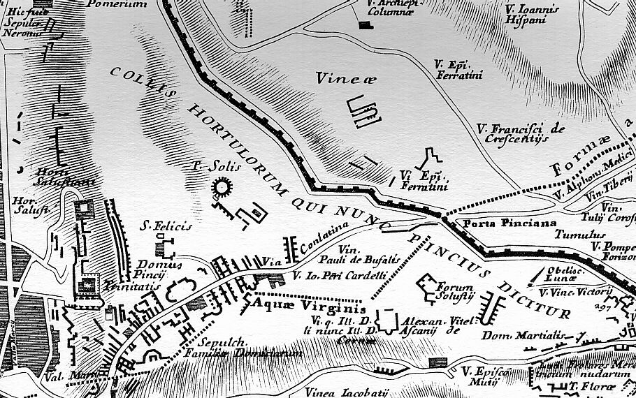
detail of Nolli's reduced copy of Leonardo Bufalini's Urbis Ichnographia
Bufalini--Nolli--Piranesi 02
Piranesi acquired a detailed knowledge of Bufalini's Ichnographia Urbis of 1551 via his direct involvement with Nolli's Pianta Grande di Roma of 1748. A decade later, in 1758, Piranesi began his Ichnographia Campus Martius where, in some instances, he utilized Bufalini's map/plan as source material for the redrawing of ancient Rome's urban plan. Bufalini's plan, especially in the open areas all around the built-up section of Medieval and Renaissance Rome, includes 'reconstructions' of the larger ancient edifices like the imperial baths and stadiums, and some temple complexes. There are also near countless unnamed, fragmentary plans of ancient remains; remains, moreover, that, after consulting Nolli's plan, appear to no longer exist in Piranesi's time. It is from a select group of plan fragments on the Mons Pinicus or Collis Hortulorum of the Ichnographia Urbis that Piranesi imaginatively redraws the Horti Luciliani, the Sepulchrum Neronis, a Basilica along the Via Flaminia, the Horti Pincii, and the Monumentum Comitis Herculis.
Piranesi's resultant redrawn plans suggest a methodology whereby the fragmentary plans of Bufalini were used as kernels of ancient fact that, in turn, galvanized newly interpreted redrawings of what once was. As suggested by Dixon, "as there were great gaps in the knowledge of the past, great leaps were then needed to supply the holistic vision of the past which was the aim of scholars--archaeologists and historians--like Piranesi. In the Ichnographia, Piranesi filled the gaps..." Furthermore, from a strictly design point of view, Piranesi used some the fragmentary plans of Bufalini as contiguous elements which, when mirror-copied and multiplied, manifest the beginnings of the new plans.
Besides Bufalini's plan delineations, Piranesi also makes use of Bufalini's labelings. Bufalini labels all his full plan reconstructions of ancient buildings, often labels the fragmentary plans, and even labels blank locations (indicating the spot of an ancient edifice although actual remains no longer then existed). In utilizing the labels within the area of the Mons Pinicus or Collis Hortulorum, however, Piranesi hardly remains faithful to Bulafini's data. For example, where Bufalini positions the Horti Salustiani and Domus Pincii, Piranesi places the Horti Luciliani and, in turn, places the Horti Salustiani and Domus Pincii further east; the street Bufalini labels Via Conlatina, Piranesi labels Via Flamina; where Bufalini positions the Sepulcr. Neronis, Piranesi places the Bustum Caesaris Augusti and, in turn, labels an unnamed fragment along his Via Flaminia Sepulchrum Neronis; a small round structure Bufalini labels T. Solis, Piranesi labels Aula within the Horti Luciliani and, in turn, labels a newly imagined round building further south Delubrum Solis. It is honestly difficult to discern whether Piranesi is here playfully inverting Bufalini's data or actually rectifying Bufalini's "facts" with advanced knowledge of the past. Like Bufalini, Piranesi groups the Domus Martialis, Ludus Florae and the Templum Florae together, but he positions the group further west and moves the Domus Martialis south rather than north of the Ludus Florae. And where Bufalini locates the Sepulch. Falimiae Domiciarum, Piranesi places a very small Sepulcr. Familiae Aenobarb. and a very large Sep. Cnei Domitii Calvini whose plan Piranesi bases on an unrelated fragment of the Forma urbis.
12 September 2022
If Piranesi was still somehow involved with the etchings of Robert Adam's designs for Syon House in 1778, then that involvement happened sometime around now.
|